
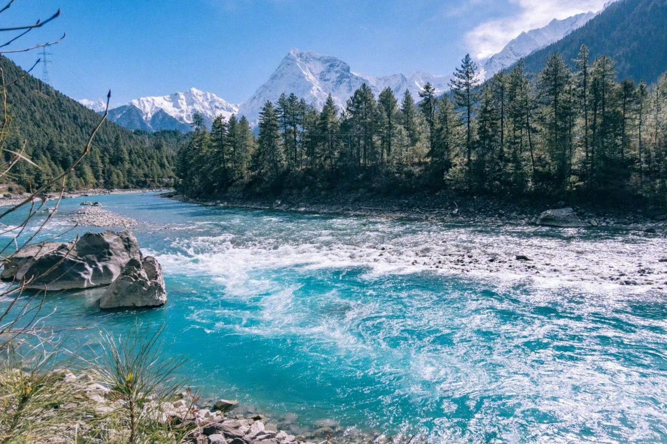
The Yarlung Tsangpo River, Tibet’s Great River
The Yarlung Tsangpo River (Tibetan: ཡར་ཀླུང་གཙང་པོ་; Chinese: 雅鲁藏布江) is one of the most important rivers of the Tibetan Plateau. Flowing across southern Tibet from west to east, it passes through high mountain valleys, agricultural plains, and spectacular Himalayan landscapes before turning south through the eastern Himalayas.
The river is the upper course of the Brahmaputra river system. After leaving Tibet, it enters the Indian state of Arunachal Pradesh, where it is known as the Siang or Dihang in different descriptions. Farther downstream, it becomes the Brahmaputra in Assam and continues into Bangladesh as part of the Jamuna river system.
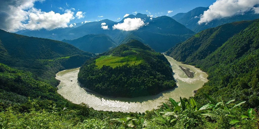
The Yarlung Tsangpo is famous for its dramatic bend around Namcha Barwa, near the eastern end of the Himalayas. Here, the river cuts through towering mountains to form the Yarlung Tsangpo Grand Canyon, one of the world’s most remarkable river gorges.
Beyond its scenery, the river is scientifically important. Its course provides evidence of the powerful geological processes that have shaped Tibet, including the collision of the Indian and Eurasian tectonic plates, the uplift of the Tibetan Plateau, and the erosion of the Himalayan mountain belt.
Understanding the Yarlung Tsangpo means exploring both its cultural significance and the geological forces that continue to shape the landscape.
Yarlung Tsangpo River: Geography and Key Facts
The Yarlung Tsangpo flows across southern Tibet, passing through the regions of Ngari, Shigatse, Lhoka, and Nyingchi before reaching the eastern Himalayas. Its course follows a broad eastward route across the southern Tibetan Plateau. Near Namcha Barwa and Gyala Peri, the river turns sharply south and descends through a series of deep gorges before entering India.
The river valley includes fertile agricultural areas, traditional Tibetan settlements, wetlands, and forested mountain slopes. These landscapes contrast with the high, relatively dry interior of the Tibetan Plateau.
Key Facts About the Yarlung Tsangpo River
| Feature | Details |
|---|---|
| Common English name | Yarlung Tsangpo River |
| Alternative English spelling | Yarlung Zangbo River |
| Tibetan name | ཡར་ཀླུང་གཙང་པོ་ |
| Chinese name | 雅鲁藏布江 |
| Source | Angsi Glacier, western Tibet |
| General flow direction in Tibet | West to east |
| Major geographical regions | Ngari, Shigatse, Lhoka, and Nyingchi |
| Famous mountain landmark | Namcha Barwa |
| Major natural feature | Yarlung Tsangpo Grand Canyon |
| Downstream names | Siang or Dihang, then Brahmaputra |
| Geological setting | Indian–Eurasian plate collision zone |
The Yarlung Tsangpo is commonly described as the longest river in Tibet. Measurements depend on whether a source refers only to the Tibetan section or to the wider Brahmaputra river system.
Where Does the Yarlung Tsangpo River Begin?
The Yarlung Tsangpo originates at Angsi Glacier in western Tibet, southeast of Mount Kailash and Lake Manasarovar. This source identification is used in modern geographical references, replacing older accounts that identified other glaciers as the river’s principal source.
From its headwaters, the river flows generally eastward across southern Tibet, following a broad valley between the Himalayan mountain range to the south and the elevated interior of the Tibetan Plateau to the north. As it travels east, the river receives water from numerous tributaries. These tributaries drain surrounding mountain ranges and valleys, contributing to the river’s flow and shaping the landscapes through which it passes.
Major Tributaries
Several tributaries are important to the Yarlung Tsangpo river system:
- Raka Tsangpo: A tributary joining the river in the Shigatse region.
- Lhasa River (Kyichu): Flows through the Lhasa area before joining the Yarlung Tsangpo near Qüxü County.
- Nyang River: Joins the main river in the Nyingchi region.
- Nyang Chu: Flows through the Shigatse region and joins the Yarlung Tsangpo near Shigatse.
These tributaries connect the main river with a broad network of mountain catchments and agricultural valleys. From Tibet to the Brahmaputra The river’s most dramatic change occurs near Namcha Barwa and Gyala Peri, where it turns south through the eastern Himalayas.
After leaving Tibet, the river enters Arunachal Pradesh in northeastern India. It is known there as the Siang or Dihang, before the combined river system farther downstream becomes the Brahmaputra in Assam. This transition connects the high Tibetan Plateau with the extensive river plains of northeastern India and Bangladesh.
A Tibetan Legend About the Origin of the Yarlung Tsangpo
The Yarlung Tsangpo is not only a geographical landmark but also part of the cultural imagination of Tibet. Traditional stories about the natural world express the close relationship between people, water, mountains, and wildlife.
One legend associated with the river describes an ancient world covered by a vast sea. Forests, grasslands, and animals flourished along its shores until a terrifying five-headed poisonous dragon emerged from the water. The dragon’s violent waves destroyed forests, flooded grasslands, and threatened the animals living nearby. As the creatures faced disaster, five colorful clouds appeared in the sky and transformed into five celestial maidens.
Using their supernatural powers, the maidens defeated the dragon and drove back the sea. The grateful animals asked them to remain on earth and continue protecting the land. According to the story, the maidens’ tears flowed across the landscape and eventually became the Yarlung Tsangpo River.
This is a traditional legend, not a scientific explanation of the river’s formation. Its significance lies in the way it portrays water as a source of life and protection in the Tibetan landscape. The river’s actual geological history is equally remarkable, involving the movement of continents, the rise of mountains, and the gradual reshaping of the plateau by erosion.
The Geological Origins of the Yarlung Tsangpo
The Yarlung Tsangpo developed within one of the most geologically active regions on Earth: the collision zone between the Indian and Eurasian tectonic plates. Millions of years ago, the Indian Plate moved northward toward Eurasia. The oceanic region separating the two continental masses gradually closed, eventually leading to continental collision and the development of the Himalayan mountain belt.
This process contributed to the uplift of the Tibetan Plateau and created a landscape of high mountains, deep valleys, and major river systems.
The Collision of India and Eurasia
The collision between India and Eurasia transformed the region’s topography. Ancient marine environments were replaced by mountain belts, elevated plateaus, and extensive drainage systems. The Yarlung Tsangpo flows through a major geological corridor associated with this collision. Faults, fractured rock, differences in rock strength, and changing elevations all influence the river’s course and erosion behavior.
As the surrounding terrain changed, the river continued to erode its valley and transport sediment downstream.
Why Does the River Flow East?
Across much of southern Tibet, the Yarlung Tsangpo flows eastward, roughly parallel to the main Himalayan mountain range. Its route reflects the interaction between regional topography, tectonic deformation, and the evolution of drainage systems. Rather than flowing directly south across the Himalayas from its source, the river follows the plateau’s southern margin before turning through the eastern Himalayan mountains.
The result is an extraordinary transition from broad plateau valleys to a deeply incised canyon.
Did the Yarlung Tsangpo Once Flow Westward?
The ancient drainage history of the Yarlung Tsangpo is a complex subject in geological research. Older geographical interpretations proposed that the river passed through several stages, potentially including an early westward-flowing system, a period of internal drainage, and the eventual establishment of its modern eastward route.
These ideas offer a framework for understanding how tectonic uplift and changing drainage boundaries may have influenced the river. However, the precise ancient routes, timing, and sequence of events remain subjects of investigation. A complete reversal from eastward to westward flow should not be treated as an established scientific fact without specific supporting evidence.
Stage One: Proposed Early Drainage Systems
Some older interpretations suggested that ancestral rivers in southern Tibet may have drained westward toward systems associated with the Indus River. Such a route would have depended on the relative elevation of the surrounding terrain. If tectonic uplift changed the gradient of an ancient valley, water could have been redirected toward a different drainage basin.
However, reconstructing the earliest river systems is difficult because erosion, sedimentation, and later tectonic activity can destroy or alter evidence of former channels.
Stage Two: Ancient Lakes and Internal Drainage
Another proposed stage involves the development of enclosed basins in which water accumulated rather than flowing directly to the sea. As parts of the Tibetan Plateau rose and deformed, mountain barriers may have restricted drainage in some areas. Ancient lakes could then have developed in low-lying basins.
Lake sediments can preserve evidence of past water levels, climate conditions, and changes in surrounding landscapes. By studying these deposits, geologists can investigate how the plateau’s drainage systems evolved. The precise distribution and timing of ancient lakes associated with the Yarlung Tsangpo early history require careful evaluation of geological evidence.
Stage Three: Establishment of the Modern River System
The modern eastward course of the Yarlung Tsangpo and its connection with the Brahmaputra system developed through a complex interaction of river erosion, tectonic uplift, and changing drainage connections. One important process is head ward erosion. As a river cuts backward into a mountain slope, it can extend its drainage network toward higher ground and potentially capture water from a neighboring river system.
Such processes may have contributed to the development of river connections in the eastern Himalayas. Nevertheless, the exact history of the Yarlung Tsangpo cannot be reduced to one simple reversal event. Modern geological studies use sediment deposits, rock formations, river terraces, and other evidence to investigate these changes.
The Yarlung Tsangpo Grand Canyon and Himalayan Uplift
The Yarlung Tsangpo Grand Canyon is the most spectacular expression of the interaction between the river and the Himalayan mountains. Near Namcha Barwa and Gyala Peri, the river makes a dramatic bend around the eastern end of the Himalayas. It then descends through steep mountain terrain, cutting a deep gorge through the eastern Himalayan ranges.
The canyon is widely recognized for its extraordinary depth and length. Different measurements describe different sections of the gorge, so its total length and maximum depth should be quoted with reference to a specific measurement method.
How Did the Grand Canyon Form?
Three major processes help explain the canyon’s development.
1. Tectonic uplift
The collision of the Indian and Eurasian plates contributed to the rise of the Himalayas and the Tibetan Plateau. As the mountains rose, the river’s route crossed increasingly steep and rugged terrain.
2. River incision
The Yarlung Tsangpo eroded the underlying rock as it flowed through the mountains. Where the river maintained a channel while the surrounding landscape rose, erosion helped create a deeply incised gorge.
3. Weathering, rainfall, and landslides
Water, weathering, rockfalls, and landslides continually remove material from steep slopes. In the eastern Himalayas, substantial rainfall also contributes to erosion and sediment transport. Together, these processes have created the canyon’s dramatic relief, narrow passages, exposed rock faces, and steep mountain walls.
Why Is the Canyon Important to Science?
The Yarlung Tsangpo Grand Canyon provides a natural setting for studying how rivers respond to mountain building. Its geology offers evidence relevant to questions about tectonic uplift, erosion rates, changing river levels, and the relationship between surface processes and deeper crustal activity.
The canyon is also an important ecological transition zone. Its large range of elevations and climatic conditions supports different vegetation communities, from high-altitude environments to warmer and wetter forests at lower elevations.
River Terraces, Alluvial Fans, and Ancient Sediments
The Yarlung Tsangpo valley contains a variety of land forms that record the river’s changing relationship with the surrounding landscape. These include river terraces, alluvial fans, floodplains, and sediment deposits associated with former lakes and tributary valleys.
River Terraces
River terraces are relatively flat surfaces that stand above the modern river. They often represent older floodplains that became elevated relative to the channel as the river cut deeper into its valley. Terraces can preserve evidence of earlier river levels and sediment accumulation. By measuring their elevations and dating associated sediments, scientists can investigate the history of river incision and landscape development.
Alluvial Fans and Tributary Deposits
Where tributaries enter the main valley, they may deposit gravel, sand, and finer sediment to form alluvial fans. These features create small areas of relatively flat terrain within otherwise steep valleys. They also record changes in sediment supply, flood activity, and erosion on surrounding slopes.
Ancient Lake Deposits
Sediments from former lakes can preserve clues about the environmental conditions that existed before the modern drainage system developed. Depending on their age and composition, these deposits may contain fossils, minerals, and other evidence of past climate and water levels.
Together, river terraces, alluvial fans, and ancient lake deposits help researchers reconstruct the long geological history of the Yarlung Tsangpo and the Tibetan Plateau.
Why the Yarlung Tsangpo Matters Today
The Yarlung Tsangpo remains important to the natural environment, communities, and economy of southern Tibet.
Agriculture and Local Communities
River valleys provide relatively fertile land and water for agriculture. Settlements along the Yarlung Tsangpo and its tributaries have developed in response to the availability of water, suitable terrain, and transport routes. The river’s influence is especially visible in the agricultural valleys of southern Tibet, where water and flat land are valuable resources.
Biodiversity and Ecosystems
The river connects high-altitude plateau environments with the forested valleys of the eastern Himalayas. Its basin contains substantial variation in altitude, rainfall, temperature, and vegetation. These environmental gradients contribute to its ecological importance and create habitats for different plant and animal communities.
Hydropower and Water Management
The river’s steep elevation changes give it considerable hydropower potential. At the same time, major infrastructure projects on an international river system raise questions about environmental effects, sediment transport, water management, and downstream communities. The river is part of a wider trans boundary system connecting China, India, and Bangladesh. Decisions about its water resources can therefore have implications beyond Tibet.
Frequently Asked Questions About the Yarlung Tsangpo River
Where is the Yarlung Tsangpo River located?
The Yarlung Tsangpo flows across southern Tibet in the Tibet Autonomous Region of China. It travels mainly eastward before turning south through the eastern Himalayas and entering India.
Where does the Yarlung Tsangpo River originate?
The river originates at Angsi Glacier in western Tibet, southeast of Mount Kailash and Lake Manasarovar.
Is the Yarlung Tsangpo the same river as the Brahmaputra?
Yes. The Yarlung Tsangpo is the upper course of the Brahmaputra river system. After leaving Tibet, it is known as the Siang or Dihang in Arunachal Pradesh and becomes the Brahmaputra farther downstream in Assam.
Why is the Yarlung Tsangpo River famous?
The river is famous for its high-altitude course across the Tibetan Plateau, its dramatic bend around Namcha Barwa, and the Yarlung Tsangpo Grand Canyon. It is also important for geological research into Himalayan uplift, river erosion, and the evolution of drainage systems.
Did the Yarlung Tsangpo once flow westward?
Some older geological interpretations propose that ancestral river systems in southern Tibet may have flowed westward or followed drainage routes different from those seen today. However, the precise ancient routes and timing remain subjects of research, so a complete river reversal should not be presented as an established fact.
How did the Yarlung Tsangpo Grand Canyon form?
The canyon formed through the combined effects of tectonic uplift, river incision, weathering, rainfall, and landslides. As the Himalayan landscape developed, the river cut deeply into the mountains, producing a remarkably steep and rugged gorge.
Which mountains are associated with the Yarlung Tsangpo Grand Canyon?
Namcha Barwa and Gyala Peri are the principal mountain landmarks associated with the river’s dramatic bend and the surrounding canyon landscape.
Why is the Yarlung Tsangpo important to Tibet?
The river supports agriculture, settlements, ecosystems, and water resources in southern Tibet. It is also a major geographical feature and an important natural record of the geological processes that shaped the plateau and the Himalayas.
Conclusion: The Yarlung Tsangpo, a Window Into Tibet’s Geological Past
The Yarlung Tsangpo is one of Tibet’s most remarkable rivers. From its source at Angsi Glacier to its eastward journey across the plateau and its dramatic descent through the eastern Himalayas, the river reveals the powerful interaction between water, mountains, and tectonic forces. Traditional legends describe the river as a gift from celestial maidens, while geological research examines how continental collision, mountain uplift, and river erosion shaped its course.
Although important questions remain about the river’s ancient drainage history, its significance is unmistakable. The Yarlung Tsangpo sustains communities and ecosystems, connects Tibet with the Brahmaputra basin, and offers a natural setting for understanding the evolution of the Himalayan landscape.
From the broad valleys of southern Tibet to the spectacular Yarlung Tsangpo Grand Canyon, this great river provides a remarkable window into the natural history of the Tibetan Plateau.