
What Is the Jinsha River?
The Jinsha River (金沙江, Jīnshājiāng), meaning “Golden Sand River,” is the name used in Chinese for the upper reaches of the Yangtze River. It flows through parts of Qinghai, the Tibet Autonomous Region, Sichuan, and Yunnan in western China, crossing a landscape of high mountains, deep valleys, and steep-sided gorges.
In Tibetan, the river is known as Dri Chu (འབྲི་ཆུ་), a name associated with the upper Yangtze. The Jinsha River is an important geographical feature of eastern Tibet, particularly around the Chamdo region, where its deep valleys and tributaries shape the surrounding landscape.
The name “Jinsha” has a historical connection with alluvial gold. During the Song dynasty, the river attracted gold prospectors who searched its waters and sediments for gold particles. Gold panning remains part of the river’s wider historical association, although any prospecting activity must comply with applicable laws and local regulations.
Beyond its natural resources, the Jinsha River is notable for its geological landscapes, role in the upper Yangtze River system, and historical significance along routes connecting Sichuan with eastern Tibet.
Where Is the Jinsha River?
The Jinsha River flows through the eastern Tibetan Plateau and southwestern China. Its traditional starting point is the confluence of the Tongtian River and the Batang River in Qinghai, at an elevation of approximately 4,500 meters. From there, it flows south through deep mountain valleys before turning through Yunnan and then northeast along parts of the Sichuan–Yunnan boundary. Farther downstream, it joins the Min River at Yibin in Sichuan, where the combined river continues as the Yangtze.
In eastern Tibet, the river is closely associated with the Chamdo region and the surrounding mountain corridors. It passes through a landscape shaped by tectonic forces, erosion, tributary streams, and seasonal changes in river flow.
Jinsha River: Key Geographic Facts
| Feature | Details |
|---|---|
| English name | Jinsha River |
| Chinese name | 金沙江 |
| Tibetan name | Dri Chu (འབྲི་ཆུ་) |
| River system | Yangtze River |
| Traditional starting point | Confluence of the Tongtian and Batang rivers in Qinghai |
| Source elevation at this confluence | Approximately 4,500 m |
| Approximate length of the Jinsha River | 2,290 km |
| Total length including the Tongtian–Dam Qu headwater system | Approximately 3,454 km |
| Main regions along its course | Qinghai, Tibet Autonomous Region, Sichuan, and Yunnan |
| Notable landscapes | Deep gorges, steep mountain valleys, river terraces, and wider basins |
| Major geographical significance | Upper course of the Yangtze River |
Why Is It Called the Golden River?
The Chinese name Jinsha Jiang is commonly translated as “Golden Sand River” or “Gold Dust River.” The name is connected to the history of alluvial gold prospecting rather than simply the color of the riverbanks. Alluvial gold is gold that has been eroded from rock and transported by water before accumulating in river sediments. Historically, prospectors searched suitable stretches of the Jinsha River for these small gold deposits.
The river’s reputation for gold attracted people to its banks and contributed to its place in regional history. Historical Chinese records also used other names for the river, including Hei Shui (黑水), meaning “Blackwater,” and Lu Shui (泸水).
Today, the name Jinsha remains an important part of the river’s identity. However, visitors should not assume that gold panning is permitted at any particular location. Activities involving mineral extraction may be subject to environmental protections, land-use restrictions, and other legal requirements.
The Jinsha River in Chamdo, Eastern Tibet
The Jinsha River forms part of the geographical setting of eastern Tibet, where high mountain ranges and deeply incised valleys create challenging terrain.
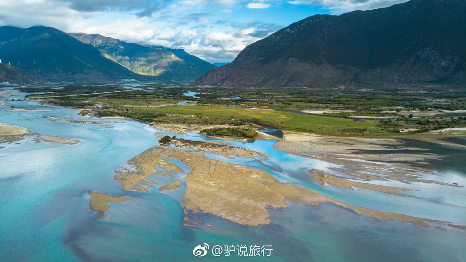
Around Chamdo, the river landscape alternates between narrow gorges and wider sections of valley floor. In some places, the river cuts through bedrock beneath steep slopes. Elsewhere, tributaries have deposited sediment that creates alluvial fans, river terraces, and small areas of flatter land.
These differences influence where settlements, farmland, roads, and bridges can be established. A regional geographical account describes approximately 587 kilometers of the Jinsha River’s course in the Chamdo area. It divides this section into three broad landscape zones. The measurements below refer to that regional description rather than to the entire Jinsha River.
Three Distinct Landscapes Along the Jinsha River
The Upper Section: Gorges and Wider Valleys
The regional account describes the upper section as extending from the Gaiha River junction near Dengke Township in Jiangda County toward the Baichu River junction near Dege. Its reported length is approximately 207 kilometers. This section alternates between narrow gorges and more open valleys. In confined stretches, the river cuts into bedrock and is bordered by steep mountain slopes. In wider sections, the valley floor offers more room for tributary deposits, river islands, floodplains, and human activity.
The Dengke wide valley is a notable example. The regional account describes it as approximately 40 kilometers long, with a relatively open valley floor and landforms shaped by river flow and sediment deposition. Alluvial fans form where streams carry sediment from mountain slopes into a main valley and deposit it as their flow slows. River islands and floodplains develop through the movement and accumulation of sediment over time. Together, these landforms illustrate how water and geological structure shape the river valleys of the eastern Tibetan Plateau.
The Middle Section: Deep, Steep-Sided Canyons
The middle section in the regional account extends from the Baichu River junction near Dege toward the Maqu River junction near Batang. Its reported length is approximately 291 kilometers. This stretch is characterized by narrow valleys and deeply incised gorges. The account describes some valley sections as lying approximately 1,500–2,000 meters below the surrounding terrain.
The steep slopes and confined river channel reflect long-term erosion and the region’s complex geological structure. Tributaries cut into the mountainsides, while the main river continues to deepen its valley. The scenery can be dramatic, but the terrain also presents practical challenges. Landslides, rockfalls, and debris flows can occur in steep mountain environments, particularly when slopes are weakened by weathering, heavy rainfall, or other disturbances.
Roads and settlements must contend with limited space between the river and the surrounding mountains. These conditions help explain why transportation routes in eastern Tibet often follow narrow river valleys.
The Lower Section: Narrow Valleys and River Terraces
The lower section described in the regional account runs from the Maqu River junction near Batang toward the river’s downstream boundary in the area covered by the source. Its reported length is approximately 87 kilometers. Here, narrow valleys alternate with gorge sections. Some parts of the valley floor are relatively limited in width, leaving only small areas suitable for river terraces, tributary deposits, and farmland.
Near the Zhuba Long Jinsha River Bridge in the Batang area, the river landscape includes sections where the channel and adjacent valley floor become more open. Floodplains and river islands may be visible depending on local conditions and water levels. River terraces are step-like landforms along a valley that mark former river levels or periods of sediment accumulation and erosion. They can provide relatively level ground in an otherwise steep landscape. The combination of river channels, terraces, and high mountain slopes gives this section a distinctive appearance.
The boundaries and lengths of these three sections are based on the supplied regional description. They should not be interpreted as a universally standardized division of the entire Jinsha River.
Natural Environment and River Resources
The Jinsha River basin contains a range of environments, from high-altitude mountain areas to warmer valleys farther downstream. In the Chamdo region, differences in elevation, slope, water availability, and exposure create varied habitats.
Forests and Agriculture
In wider valleys, suitable soils and access to water can support agriculture. Forests occupy some surrounding slopes, while steeper terrain and higher elevations support different types of vegetation. The amount of land available for cultivation varies considerably. Narrow gorges provide little flat ground, whereas wider valley sections may contain terraces, alluvial deposits, and settlements.
Fish and Aquatic Habitats
The river system supports freshwater habitats, including fish adapted to the conditions of the upper Yangtze basin. River health depends on water quality, flow patterns, habitat connectivity, and the condition of the surrounding landscape. Specific species and their distributions should be confirmed through reliable regional ecological sources before making detailed claims about a particular section of the river.
Hydropower and Water Resources
The Jinsha River is also important for hydropower generation. Large hydropower projects have been developed along its course, reflecting the river’s substantial flow and elevation differences. Such development brings changes to river systems and surrounding areas. Understanding the Jinsha River therefore involves not only its scenery and geology, but also its role in regional energy production and water-resource management.
The Historic Eighteenth Army Crossing in Jiangda County
One historical site associated with the Jinsha River in Jiangda County is the Eighteenth Army crossing site, connected with the People’s Liberation Army’s advance into Tibet in the early 1950s.
The river has long served as a major geographical barrier between parts of the Tibetan Plateau and neighboring regions. Its steep banks, powerful currents, and limited crossing points made river crossings significant events in the history of movement through eastern Tibet.
The crossing site forms part of the historical narrative associated with the Sichuan–Tibet route and the political and military changes that took place in the region during the early 1950s. For visitors interested in modern Tibetan history, the site offers a way to explore how the river landscape influenced travel and military movement. Its interpretation should be understood within the broader historical context of the period.
Travelers should check local access arrangements and available interpretation before planning a visit, as visitor facilities and access conditions may change.
The Jinsha River and the Sichuan–Tibet Route
The Jinsha River is an important geographical feature for travelers moving between Sichuan and eastern Tibet. Its valleys form part of a landscape of mountain roads, bridges, settlements, and historic crossing points. Travel along the Sichuan–Tibet route can reveal major changes in elevation and terrain. Broad river valleys give way to narrow gorges, while roads pass through areas where steep slopes leave little space for infrastructure.
For travelers exploring the Chamdo region, the Jinsha River offers insight into the geography that has shaped routes across the eastern Tibetan Plateau.
Practical Travel Tips
- Allow time for scenic stops: The river landscape changes between wide valleys, river terraces, and narrow gorges.
- Choose safe viewpoints: Stay in designated or stable viewing areas and keep away from unstable slopes and exposed riverbanks.
- Check road conditions: Rainfall, landslides, rockfalls, and other mountain hazards can affect travel.
- Respect local regulations: Do not undertake unauthorized gold panning or enter restricted areas.
- Explore the historical context: Learn about the Eighteenth Army crossing and the history of the Sichuan–Tibet route through reliable local interpretation.
- Prepare for high altitude: Eastern Tibet includes high mountain terrain, changing temperatures, and long driving distances.
- Confirm travel requirements: International visitors should verify current Tibet travel permits and entry requirements for their nationality and itinerary before departure.
Frequently Asked Questions About the Jinsha River
What is the Jinsha River?
The Jinsha River is the Chinese name for the upper reaches of the Yangtze River. It flows through the eastern Tibetan Plateau and southwestern China, including parts of Qinghai, the Tibet Autonomous Region, Sichuan, and Yunnan.
What does Jinsha River mean?
Jinsha Jiang (金沙江) is commonly translated as “Golden Sand River.” The name is historically associated with alluvial gold found in river sediments and the gold prospectors attracted to the area.
What is the Tibetan name for the Jinsha River?
The river is associated with the Tibetan name Dri Chu (འབྲི་ཆུ་), used for the upper Yangtze. English-language references may use different transliteration conventions.
Where does the Jinsha River begin?
The Jinsha River is traditionally considered to begin where the Tongtian River and Batang River meet in Qinghai, at approximately 4,500 meters above sea level. Some measurements include the upstream Tongtian–Dam Qu headwater system and therefore give a greater total length.
How long is the Jinsha River?
The Jinsha River is approximately 2,290 kilometers long under the measurement given in the English-language Wikipedia article. The total length is approximately 3,454 kilometers when the Tongtian–Dam Qu headwater system is included.
What landscapes can be seen along the Jinsha River in eastern Tibet?
The river passes through narrow gorges, steep-sided valleys, wider basins, river terraces, and areas of alluvial deposition. The scenery varies with the local geology, elevation, and river conditions.
Why is the Jinsha River important to Chamdo?
The river shapes the region’s valleys and drainage network and influences settlement, agriculture, transportation, and access between mountain areas. It is also associated with historical crossing sites along routes connecting Sichuan and eastern Tibet.
Can visitors pan for gold in the Jinsha River?
Visitors should not assume that gold panning is permitted. Mineral prospecting may be regulated or prohibited at particular locations, so travelers should check the applicable laws and local rules before undertaking any such activity.
What is the Eighteenth Army crossing site?
It is a historical site in Jiangda County associated with the crossing of the Jinsha River during the People’s Liberation Army’s advance into Tibet in the early 1950s. Visitors interested in the site should consult reliable historical sources and current local visitor information.
Explore the Jinsha River and Eastern Tibet
The Jinsha River reveals the dramatic geography of the eastern Tibetan Plateau. Its deep gorges, wider valleys, river terraces, and tributary systems show how water and geological processes have shaped this mountainous region over time.
The river also connects natural landscapes with human history. Its gold-prospecting legacy, importance to transportation routes, and association with the Eighteenth Army crossing make it relevant to visitors interested in both geography and modern Tibetan history. For travelers exploring eastern Tibet, the Jinsha River provides a valuable perspective on the region’s terrain and its connections with the wider Yangtze River system.
Planning a trip through eastern Tibet? Explore the Chamdo region and the Sichuan–Tibet route with careful attention to local conditions, historical context, and responsible travel.